Friday, October 27, 2017

The David Rumsey Map Collection

by Heather Murphy

As genealogists, knowing where things happened in the lives of our ancestors is vital to being able to learn more about those events.  Another great feature of combining technology and genealogical research is the ability to not only find current maps of the places we research, but also historical maps that were created closer to the time period in which we are searching.  The David Rumsey Map Collection is an amazing collection of maps that is worth using to gain a sense of place for your research.

The David Rumsey Map Collection, a private collection donated to Stanford University, is a collection of over 150,000 maps from around the world covering a time span mostly from the 16th century to the present.  The website for the collection, www.davidrumsey.com, contains over 80,000 images.  Viewers have several different options how to interact with the images, such as ordering prints or downloading files (when copyright allows), compiling slide shows or media groups, and overlaying maps to compare between them.

While there are many different viewers available, a good place to start is to use the LUNA Browser.  On the homepage look for a link under "Quick Links" on the right side of the page.  Read the brief information on the page including a few suggestions on how you can use the images and some tips on how to use the LUNA Browser.  Then click on the brown button near the middle of the screen titled, "Launch LUNA Browser."

Within the LUNA Browser is the ability to search the images.  In the upper right-hand corner is a search engine.  On the left side of the screen are categories that can filter your results.  It is sometimes beneficial to use both the search engine and the refining categories.  Also along the top of the Browser are options titled Collections, Explore, Create, Share, Embed, Print which you can explore, though not every option is available for every image.  It is amazing how many ways viewers are encouraged to use and share these beautiful images.

You can find more than maps showing geographic boundaries.  There are railroad maps, waterways, cartoon maps, advertising maps, atlases, and more.  Below is a page from a county atlas which included drawings of homes and sketches of individuals.

Combination Atlas Map Of Yates County New York. Compiled, Drawn and Published From Personal Examinations and Surveys. 1876.
David Rumsey Historical Map Collection


It allowed me to created a Media Group, in which I collected a few images of Washington in different decades.  I then chose the Embed option, and it gave me code to create the image box below.  Clicking on an image will take you to the website where you can take a closer look and save or share the image.


The features of the David Ramsey Map Collection are too numerous and detailed to cover in one blog post.  Take some time to peruse through their holdings.  I guarantee you will find some amazing maps to complement your genealogical research.

Monday, October 16, 2017

TCGS 2017 Seminar - Understanding Your DNA

by Heather Murphy

We had a wonderful seminar on Saturday presented by Diahan Southard.  Diahan thoroughly explained to over ninety attendees how DNA results can help with genealogy research and also their limitations.  We learned the differences between the various testing companies, how to analyze DNA matches within Ancestry.com and use them to help with specific questions in our family trees, and even had a hands-on workshop.  Thank you to the seminar committee for putting on an excellent event!  Diahan does on-line consulting and has several DNA quick guides available for purchase at www.yourdnaguide.com.

Seminar attendees

Heritage Books provided a wide selection of books for purchase

Diahan's booth was always busy

Thanks to Art Kelly for a wide selection of items for the silent auction


Friday, October 13, 2017

Share the Wealth

Have you read a blog post that you have found interesting or useful?  Now at the bottom of each blog post you can chose popular social media sites and share with your friends what you have learned.  Go ahead and help others to learn more about researching their family history.

Finding Place Names: Using GNIS and GNS Databases to Identify Places

by Heather Murphy

Have you ever come across a place name in your research you aren't sure still exists? What about a post office name given in a census that isn't the main town? A town in a country you know little about? Looking for cemeteries near your ancestral home? The Geographic Names Information System (GNIS) and NGA GEOnet Names Server (GNS) can help with each of these.

"The U.S. Board on Geographic Names is a Federal body created in 1890 and established in its present form by Public Law in 1947 to maintain uniform geographic name usage throughout the Federal Government." They have links to two main databases, one for domestic names, Geographic Names Information System (GNIS), and another for foreign names, NGA GEOnet Names Server (GNS).  Both databases also include historical places which no longer exist.

After going to their homepage, select "Search Domestic Names" to search for places within the United States. Search parameters include feature name, state, county, and feature class. You can enter as much or as little data depending on your goal. You can enter a feature name alone or narrow it by state and county. If you want to have a list of the cemeteries in a specific county, select the feature class as cemetery and specify the state and county.


Below are the results for cemeteries in Benton county, Washington.  In contrast, a search of cemeteries in Clay County, Indiana had fifty-seven results.


Clicking on one of the entries will bring up essentially the same data as the table, but on the right side of the screen there is box titled "Mapping Services". I have had the most success with ESRI Map or ACME Mapper, but you can look through all the options to find which one you like best.

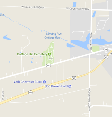
This first image is from ESRI Map, looking at the location of Cottage Hill Cemetery, Clay county, Indiana. Both ESRI and ACME have similar options for map styles.   ACME's map gives you the ability to mark several locations, which is useful to compare different locations, but it also has an advertisement in the bottom corner of the map.

"Map" view using ESRI


"Map" view using ACME


"Topo" view using either


Notice how each map view provides different information and perspectives, so look through all the different map styles for your location.  I have found the topographical maps to provide interesting information about an area, though keep in mind these do not necessarily depict the area as it would have been when your ancestor lived there.  In this map I can see abandoned train lines, mines, water features, buildings, schools, cemeteries, and much more.

If you are interested in finding a place outside of the United States, select the "Search Foreign Names" option back on the main page or go directly to the NGA GEOnet Names Server (GNS) text based search page.


You can then select the country (or not if you don't know which country to select) and then enter your place name in the "Name:" field.  For this example I am searching for "Vysocina."  I believe it is in Bohemia or Czech Republic, but since I am not sure what country it is in I did not select a country.


I now have a list of four places, all within the Czech Republic (Czechia), that have "Vysocina" as the official place name or as a variant name.  The map options for Foreign Names is not as useful as the one for Domestic Names.  The only options here are for the latitude and longitude of the place in Google Maps or Mapquest.  This can be problematic if the name is for a region because often that boundary does not show up in the supported mapping programs, but at least it gives an idea of what part of the country that place exists.

The Foreign Names database may not have as many features as the the Domestic Names database, or even a general search engine, but it might come in useful if you are having difficultly locating a certain place and you aren't having luck elsewhere.  Also, it is useful to know if several areas within a country had at least a portion of the same name, as seen above, so you don't assume that the first place that comes up in search engine results is the only place by that name.

Knowing the places our ancestors lived is so vital to finding their records and these databases are a couple more tools that can help us better understand the places we need to know more about while doing our research.

Friday, October 6, 2017

Have I Been Here Before? How Research Logs Keep You From Going in Circles

by Heather Murphy

With shaking leaves and record hints showing up in many websites it is easy to hop from link to link looking for more records.  How often do you take a couple extra minutes to note the record collections you search so you don't find yourself looking at the same thing a few months later?  Research logs aren't one of the "fun" parts of research, but if you spend a small amount of time creating them you can save yourself time in the future.

Research logs don't need to be anything fancy.  They can be handwritten, in a spreadsheet, a word document, or part of your genealogy software program.  The main elements they should contain are the date you looked at the record, the name of the record, where you accessed the record, who you looked for, and what information you found, including negative results.

PDF file
The FamilySearch Wiki has a page for Genealogy Research Forms.  The forms are organized by the
provider and then subcategories.  The first section is by FamilySearch and after scrolling down a little there is a Research Log in .pdf format (that has type-able fields) and an Electronic Research Log in .doc format.  Down further on the page there are a few additional options for research logs from other providers, such as Ancestry or Family Tree Magazine, most of which are documents that can be printed and filled in by hand.

DOC file

As much of your research is probably done on the computer, having an electronic research log can reduce the amount of time you spend notating.  Simply copy and paste the identifying information from the website into the corresponding field in the log.  Another benefit of using an electronic log is the ability to use a search feature.  If you want to know if you have checked a particular source it is easy to have the program search for a particular word or phrase without needing to scan through all your entries.

Remember to include sources that did not have the information you needed, considered negative results.  Also make entries for record collections you considered checking, but decided they would not provide the needed information.  For example,  I want a death record in 1898 in Bartholomew county, Indiana.  When I look at Ancestry's Indiana sources I see "Indiana Deaths, 1882-1920."  However, by looking at the description of this database I see that it only "includes sixty-seven of the ninety-two counties," and does not include Bartholomew county.  I would make a note of that in my research log.

Sometimes the anticipation of finding what you are looking for leads you to move as fast as you can from source to source.  Try slowing down a little bit to make a record of where you have been and what you have done and it will pay off in the long run.